2 Years After Hurricane Ian, Milton Looks Worse
10/10/24 - 6:00 am EST - Neighbor posting a video of the storm in his canal. The top river height was reported at 12.30 am, and it was 6.55 over the flood stage, which was 1.43 ft over Helene.
10/9/24 - 5:45pm EST - Storm Surge starting to come in:
 |
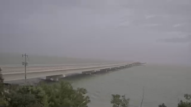
| Water coming on to the causeway entrance - McGregor Blvd. |
 |
| This canal is one block over from our house. The surge has just come up over the seawall on the house across the canal to the left. |
 |
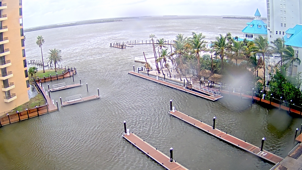
| Sanibel Harbour - Surge coming up over fixed docks. The Marriott is where the Weather Channel is broadcasting. You can see the waves licking over onto the pool deck. |
10/9/24 - 5:00pm EST—Update from NOAA: Thankfully, the inundation is decreasing. However, Tropical storm-force winds remain.

 |
| No water on McGregor going to causeway. 5:00pm EST 10/9/24 |
10/9/24 - 3:45pm EST - Water splashing over the docks at Sanibel Harbor Marina (Sanibel Causeway)

10/9/24 - 2:45pm EST—A 2 o'clock update to the forecast dramatically reduces anticipated flooding. The fast-moving storm will push less water, and the direction of the surge will be less conducive to up-river inundation.

10/9/24 - 12:30pm EST - We're getting tornado alerts one after another as the storm's outlying bands speed by the previously still air. The winds are beginning to pick up, and bands of heavy rain come through. Sanibel Harbor camera - the star witness to Ian's fury - shows wind kicking up.

10/9/24 - 8am EST - Doomscrolling. We are watching the news now, sitting in our hotel room in Boston. We take each development in the storm as it approaches and analyze it; is it better or worse for us? The storm is bigger and stronger than expected, and the wind shear we hoped would knock it down didn't materialize. But, the track remains clear, and the storm is moving faster than Ian, almost twice as fast at 14 mph versus Ian's 8 mph. Also, the eye is currently smaller, meaning the heaviest of the fastest winds will be in a smaller band. AND the storm won't sit there pounding us as Ian did for 12 hours of 150 mph winds. It will come ashore and weaken quickly.
The brightest development is that the forecast inundation is much less intense for Fort Myers and Cape Coral. Our house is back in the yellow, meaning a 3-6 foot storm surge. We had 11 feet during Ian. Maybe our neighbors, whose homes all sit at 7-8 feet over flood stage, will be spared!

10/8/24 - 12noon EST - Just saw this. Much worse than the previous impacts. Our house is 10.5 feet over flood stage:

10/8/24 - 11am EST - Gathering resources to view the storm's impacts here:
Our Neighbor - https://capeweather.com/southwest-florida-live-streaming-webcams/cape-coral-florida-webcam-rubicon-canal/
The local lock -
1.) https://www.youtube.com/live/szEroaUMN-I?si=3c8CAml1NwZUHzej
2.) https://www.youtube.com/live/p3AB2dxXH6I?si=Q2sIw_EjzJUsKLWV
10/8/24 - 8am EST- Watching the cone and trajectory. Landing is now expected between St. Petersburg and Sarasota... Closer to us, but because the track becomes more certain, the cone shows that the center is likely not coming for Cape Coral.

10/8/24 - 7am EST—Two years and a week after Ian landed in Fort Myers Beach, we are looking at another storm headed our way. Milton is projected to have a significant storm surge. We hope that we have done everything we need to ensure that our belongings are secure. We are not going to be in the path of the storm. We will watch the landfall from our TVs, just like you.
Cape Coral has mandatory evacuation after 3pm EST today.
It's important to remember that we survived Ian, which was a direct hit from a Cat 5. This storm is slightly different in that the approach is from the west, not the south. This means we should not see as much storm surge. That said, we are on the "dirty side" of the storm; unimpeded wind from the Gulf has the greatest strength and surge.

We are outside the NOAA cone, but that doesn't really mean anything.

We have done everything we can to prepare for the hurricane. We placed all of our furniture inside. I doubled the lines on the boat, removed the canvas, and emptied the freezer. What else can I do?
Our biggest worry is the storm surge. Because of our area's geography, water gets corralled up the Caloosahatchee River. With an onshore wind, that's bad, but when the wind comes from the southwest, it gets pushed directly into our harbor. We had a 13.5-ft storm surge during Ian, and this storm surge is reported to be between 5 and 10 feet. If that's the case, we will be fine.
Trying not to doom scroll.
Comments
Post a Comment